Showing posts with label toponyms. Show all posts

Sunday, 22 January 2017

Everything tastes better with rum

Rum butter - rum nickies - Cumberland sweet pie - Cumberland pilaf

Although I was brought up in Cumbria, I wasn't brought up with rum butter. When I was about 11, a school friend gave me some for Christmas, and I ate it with digestive biscuits (which were thus much improved). Last time I hosted Christmas, I made rum butter instead of brandy sauce to go with the Christmas pudding, and that's now my tradition.

This year I added rum nickies to the tradition. The coin toss had dictated that my dad made mince pies and Christmas cake, and I made the pudding - but this meant no mince pies before the visitors arrived, and as our rule is no mince pies after Christmas morning (and there were rather fewer mince pies at work this year than when I worked in London!), it meant almost no mince pies. But rum nickies aren't mince pies so we could have them before and after.

Rum nickies have come to a certain amount of attention in recent years - not exactly sticky toffee pudding, but plenty of links to recipes and products, including rum-nicky-in-a-jar. I've now got five small books of Cumbrian/Lakeland recipes (two modern ones available in all good tourist bookshops, and three local publications from the 1960s-70s).


All but one include recipes for rum nickies, and all of them concur that:
  • rum nickies are individual pastries, like mince pies
  • the filling is currants (and only currants) soaked in rum and spices
All of the online recipes concur that:
  • rum nickies are large shared pies, commonly with a lattice topping (rather than a sheet of pastry with nicks in)
  • the filling is primarily dates, with candied stem ginger and sometimes currants, sultanas or even dried apricots, soaked in rum, and surprisingly, an absence of spices
I'm intrigued by this clear split. The dates and ginger sound yummy and I'll try those another time, but I went with the currants and mine were just fine.


One of the cookbooks is a 1960s WI cookbook from my Grandma's shelf. It doesn't show the date, but it's pre-decimalisation, pre-metrification and pre-Cumbria. Many of the recipes indicate which WI contributed them - Linstock, Dacre, Scotby, Moor Row, Newton Arlosh... We particularly enjoyed some of the Gamblesby contributions, which included two separate recipes for burnet wine - we imagined two ladies competing to get their recipe included. We're still not sure what these very plentiful burnets are, we're fascinated by the function of the piece of toast, and we prefer the recipe that ends "A little rum greatly improves the wine". The more of the book you read, the more you suspect that a little rum would greatly improve many things.

Gamblesby Burnet wine 1

Gamblesby Burnet wine 2

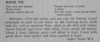
Fowl or foul? Rook or yuck?

  • Gamblesby (in Glassonby) or Gamelsby (by Aikton) is one of my favourite village names as it's so little altered from the Norse. I'm tempted to buy the Ikea Gamleby shelf purely for its name. When I went to Copenhagen some years ago, flying to an airport in the budget airport definition of 'near' and catching a train to the city, the similarity of the placenames meant I could have been on the Settle-Carlisle line. Although with newer carriages and more passengers. And our views are better.
One of Grandma's celebrated recipes was Boxing Day pasty. Every year, regardless of who was hosting Christmas, Grandma made Boxing Day pasty for our Boxing Day walk. A tray-bake mince and carrot pasty, ideally still a bit warm in the years when we had white Christmases (sledging over Devoke water, snow on top of ice), it was nothing special, but it was traditional. My brother having declared a wish to swim in the Solway on New Year's Day, some sort of pasty was going to be needed. Could I make Grandma's pasty? Or was it time to make my own tradition?

And then I read: ...Cumberland gave us rum butter to have with our Christmas pudding, and also from Cumberland came "standing pie" or "sweet pie", filled with chopped mutton, apples and raisins, the grandfather of the mince pie. Back to the historic cookbooks to find a recipe - meat and fruit together are quite fashionable at present and this one has to be tried. Although the recipes are clear that this is a large plate pie (i.e. pastry lid but not base), that wouldn't meet my need for an outdoor pasty, so individual handheld pasties were the way to go. I used the WI recipe with a cross-reference to Jane Grigson. I haven't made handheld pasties for years, and I overfilled them as usual (but I take heart from the note about avoiding headriggs from another recipe) and a couple exploded.


The recipe includes really quite a small quantity of meat to fruit, so I made double quantities, enough for nine handheld pasties, one large pie to serve 6-8 and one smaller pie for 2-4. Next time I make it I'll use more meat to fruit (tastes have changed) and include better meat and more fat (supermarket meat too lean and this needs something more to bind it and carry the flavour of the meat). And think about whether there's anything else that could bind the filling a bit more.

For example, could you use rice in a pie filling? I used a Diana Henry recipe for lamb pilaf to use up some of my roast goose glut, and then realised it was already quite close to being a recipe for Cumberland pilaf - just adjust the fruits and add rum!

A bridge too far: Carlisle’s Eden Bridges

Abstractions - holmes - floods - folk speech - rivers changing course - bridges - droving

Walking back into the city from the Vallum Gallery on Brampton Road through Rickerby Park in early October 2016, I was struck by standing water on the floodplain. Reflecting still on some of the pictures I’d been looking at, I thought about how the landscape and river route had changed, or been changed here, and about the floods. I’m thinking about abstracted map representations of Cumbria (e.g. abstracting the rivers and becks from the rest, like an arterial/venal map of the body, as part of understanding flooding), and about embellishments – embroidering over printed maps to show the floods, or embroidering over pictures to show where things happened – there I capsized my canoe, here my parents dropped my brother in a beck.

Rickerby floodplain / Carlisle from the North East Here I capsized my canoe

The lower Eden is characterised by meanders and holmes, flat semi-islands that are attractive locations for cricket pitches. Whilst the Norse 'holmr' means small island (think Stockholm), here they've become semi islands, dry patches surrounded by marshy/fen land. The shape of the land suggests the river has been flooding for very many years, and the old OS maps of Carlisle have 'liable to flooding' marked on every holme. I remember the water from the same river coming up through our cellar in Temple Sowerby when the water table rose – if there was standing water on the floodplain by the bridge, there would be water in our cellar soon.

Bizarrely, the Google satellite map of much of Carlisle is taken in the immediate aftermath of Desmond, stitched onto the next picture to the north taken at another time, and showing water where water shouldn't be. The roads have been hand-drawn back onto the image.

A strange rectangular cloud over the city  Floodwater in Rickerby park suddenly ending where the pictures are joined 

One of the things that stuck in my mind post-floods was a magazine writer being annoyed at Carlisle people referring to their bridge that was shut as “Eden Bridges” – when there’s only one bridge. And it’s true, I’ve observed one of my colleagues, who lives over the bridge, calling it Eden Bridges. Search for the reports from 7th December 2015 and half the headlines pluralised the bridge. It’s a folk memory in speech, of when there were two end-to-end bridges crossing this branch of the river, originally known as the Priest Beck, and the branch that ran round the back of the islanded Sands, where the cattle markets and bull baitings were held.

A map forming the back screen at Borderlines shows the old route of the river in the days when the city stayed within its walls and Botcherby, Etterby, Rickerby and Harraby were villages nearby. Transposed onto a modern map, the river route was something like this:


Carlisle today The walled city and divided river

Remembering pre-GCSE Geography and the theory of oxbow lakes, a far as I can currently work out, something like this happened:
  • Original route of river meanders, Priestbeck doesn't exist
  • River breaks out and creates Priestbeck, probably after a flood event - possibly around 1572 (this sketch map from 1572, south at the top, shows a breach of the river in need of repair, without a bridge over it, where Priest beck would otherwise be). On the other hand, Magna Britannica (1816) reports: "The two bridges over the Eden at Carlisle, called Eden Bridge and Prestbeck Bridge, were of wood in the reign of Queen Elizabeth; when one of them having fallen down, and the other being in a state of great decay, an act of parliament passed for rebuilding them at the expence of the county in 1600. It is probable that they were then first constructed of stone."
  • For a time, river flow is divided between the Priestbeck and the Old Eden loop (e.g. George Smith 1746 & 1752 maps , reproduced in Cattle Droving through Cumbria, Peter Roebuck, Bookcase 2016), but eventually the main flow goes over Priestbeck and the Old Eden starts to dry up (in theory forming an oxbow lake which shrinks away over time)
  • The island of the Sands is likely to be marshy and prone to flooding (as the 1752 George Smith map suggests), limiting the ways the city could use it
  • There are two bridges and frequent calls for them to be repaired and rebuilt throughout the eighteenth century, perhaps indicative of flood damage (and failure to cope with the volume of traffic, notably droving)
  • 1807 Act of Parliament approves funding of £10,000 towards the rebuilding of Priestbeck Bridge, given its strategic importance to the northbound road. The new bridge was built 1812-15 and doubled in width in 1932
  • Old Eden Bridge (south) was removed "and a raised and partly arched causeway ...formed, connecting the town with the new bridge".
  • 1865 OS has a municipal boundary (ward boundary) following (probably) the line of the old Eden. No physical sign of the old river.
  • 1898 OS has cattle market, one bridge, old racecourse and the first Hardwicke Circus roundabout which opened in 1892/93. Oddly no Drovers Lane.
  • Civic Centre opened 1964, late 1970 new road layout opened (rebuilt Hardwicke Circus, Georgian Way; Castle Way opened in 1974); Sands Centres opened 1985. Presumably further land drainage (building on stilts might have been a good idea) to secure the foundations of these various structures?
In 1997 as part of the Arch/Millennium Sheepfolds projects, Andy Goldsworthy tried to find the location of the pinfold at the civic centre - and decided it was probably under the civic centre. After photographing the journey of the Arch, the project aimed to (re)build sheepfolds in the places they once were; the Carlisle pinfold has not yet been rebuilt. With the arrival of Debenhams in 2000, Drover's Lane was built over and moved northwards and the view Goldsworthy took there is gone.


Wednesday, 28 September 2016

You Say 'Tomato', I say 'Tomato'

Recently @NotJustLakes wanted to know how we all pronounce Scafell, i.e. the Scar vs Scaw debate which I'd recently been having with my mum. The modern pronunciation is Scar (or ska!) - but western roots know it as Scaw. Twitter and Wikipedia quickly confirmed that "Formerly the name was spelled Scawfell, which better reflects local pronunciation." Someone spelled it wrongly on an eighteenth century map; unusually Ordnance Survey didn't reinstate the local pronunciation; visitors and offcomers to the second and third generation start to pronounce it how it's spelled, long-rooted locals, nearby offcomers and the curious pronounce it the old way.

There are Sca*fell Roads all over the county - about half spelled each way - and it's likely that a high proportion of those are estates built in the last 70 years, suggesting that spelling as well as pronunciation isn't long fixed.

That reminded me of Scaws Infants in Penrith - on the Scaws estate - I guess there was Scaws Juniors too (but I was too young,and they merged to become Beaconside. Between Scawfell and the Scaws estate we have two very similar names showing the east and west Viking incursions into Cumbria. Scawfell in the west is from the Norwegian Old Norse skalli fjall, where skalli is shieling (skiul in Danish) or bald (try this) or skagi fjall, where skagi is headland*. Scaws estate in the east, on the other hand, is from skoven, Danish woods (skogen in Norwegian)**

In August's Cumbria Life, Caz Graham suggested that useful things kids should learn at (Cumbrian) schools included "how to say Torpenhow, Bouth, Burgh and Skelwith in a manner that will confuse tourists". Even when you know Burgh, how about the nearby Powburgh beck? Pohbruff? P-ow-bruff?

Earlier in the year, before I left London, Lord Oakeshott asked me over dinner (I worked with his wife; I was amused to have dinner with a lord) whether my home town was pronounced PENrith or penRITH? Given that Virgin Trains and their often Scottish crew, say CarLISLE and penRITH, and that's where I'd most commonly heard the names spoken for 25 years, I found myself uncertain about the town I grew up in. Mum explained: in general in a two-syllable name we stress the first (and wherever possible we put a schwa in the second syllable). So

CARlisle, PENruth, THRELkuld, SCAWfull (allegedly; the 'full' is debated here!), WAZdull, WARcup, etc.

But there's no accounting for Aspatria, of course.


* https://en.wikipedia.org/wiki/Scafell_Pike and http://www.merriam-webster.com/dictionary/scaw
**Cumberland & Westmorland, Ancient and modern: the people, dialect, superstitions and customs (1857) Jeremiah Sullivan, p49, p95


Milli fjallanna og fjarðarins