Bridges - gates - they now built a wall from one sea to the other
A weekend of protests on several continents; a weekend designated for making marmalade, a quintessentially British preserve with a Portuguese name made from Spanish oranges and Caribbean sugar. I went into town to buy more oranges, and on autopilot got into the wrong lane and had to drive round the one-way system to get to the supermarket. I realised an exhibition at Tullie House that I kept meaning to see was due to end in a few days, so I went to look at a painting of Carlisle's Eden bridges*.
The painting is one of two from around 1800 and shows the city from Rickerby Park below Stanwix fort on the Roman border wall with the two Eden bridges in the foreground and the mountains behind. Leaving aside the river, I'm struck, oddly, by the similarity to Marrakech - another red walled medieval city with snowy mountains behind and places of worship rising above the houses.
The bridges brought traffic from Scotland to the former Sands island where the cattle marts were held - and customs duties paid (or not, if the drovers avoided the city) - and off the Sands island past the pinfold to Scotchgate. The city still has Scotchgate and Englishgate, but until today I didn't know there was an Irishgate too. I go through it every day. The actual gate was demolished in 1811 and its name lost in the building of the semi-ring road in the 1970s - although it was reincarnated in the unloved "millennium bridge", officially the Irishgate Bridge.
All three gates are double-named: English Gate is Botchergate (the road to Botcherby); Scotchgate is Rickergate (the road to Rickerby, Richard's farmstead); Irishgate is Caldewgate (the road over the river Caldew). There was no Danegate: the stone walls came after the norsemen had stopped being a threat, or had assimilated.
And after the bridges I looked at the exhibits about the shifting border, the reivers, and the original border wall.
They now built a wall across the island from one sea to the other, which being manned with a proper force, might be a terror to the foes which it was intended to repel, and a protection to their friends whom it covered...
After the Romans left and before the Normans arrived, we were one realm in these middlelands. The wall wasn't needed. When the Normans arrived, the North was harried, and emptied. The wall had a role to play again and the city walls were rebuilt in stone and frequently repaired. The Scots and the English were different folks, and fought. And the Irish, with their gate?
One day I shall walk these walls.
Nowadays we know the border is permeable; we know people who live in one country and work in the other; we know people who currently live and work in England but are thinking of moving to live in Scotland because it's more politically pleasant to them, or because their child's higher education will be more affordable, or for the chance to vote in the second referendum when it comes.
I look north for the views; my neighbours drive north for their holidays where the mountains are higher, the wilderness is greater and the eagles still fly. I look north as well as south to understand the history of the land I stand on; I get the travel news from Scotland as well as Cumbria, but my TV news comes from Newcastle and doesn't cover the whole of Cumbria, let alone the country five miles away as the curlew flies. Professionally we look south: Scotland is creating distinctiveness in its institutions and its public services compared to England, and somehow though the border on the ground is diminished, the border in the mind is strengthening. And as a result, sometime in the not too distant future, the border on the ground may return.
This year's marmalade is a whisky one, with more whisky than most recipes. Made in England, with Scotch. Before we had customs union in 1707, we had smuggling across this border. Whisky as well as cattle.
*Three days after I published this, Sir Ian McKellen on Who Do You Think You Are found that the artist James Lowes was his ancestor, and visited Tullie House to look at some of his engravings.
Read: Peter Roebuck, Cattle Droving through Cumbria 1600-1900, Bookcase 2015;
Rory Stewart, The Marches, Jonathan Cape 2016
Showing posts with label Carlisle. Show all posts
Showing posts with label Carlisle. Show all posts
Sunday, 22 January 2017
A bridge too far: Carlisle’s Eden Bridges
Abstractions - holmes - floods - folk speech - rivers changing course - bridges - droving
Walking back into the city from the Vallum Gallery on Brampton Road through Rickerby Park in early October 2016, I was struck by standing water on the floodplain. Reflecting still on some of the pictures I’d been looking at, I thought about how the landscape and river route had changed, or been changed here, and about the floods. I’m thinking about abstracted map representations of Cumbria (e.g. abstracting the rivers and becks from the rest, like an arterial/venal map of the body, as part of understanding flooding), and about embellishments – embroidering over printed maps to show the floods, or embroidering over pictures to show where things happened – there I capsized my canoe, here my parents dropped my brother in a beck.
The lower Eden is characterised by meanders and holmes, flat semi-islands that are attractive locations for cricket pitches. Whilst the Norse 'holmr' means small island (think Stockholm), here they've become semi islands, dry patches surrounded by marshy/fen land. The shape of the land suggests the river has been flooding for very many years, and the old OS maps of Carlisle have 'liable to flooding' marked on every holme. I remember the water from the same river coming up through our cellar in Temple Sowerby when the water table rose – if there was standing water on the floodplain by the bridge, there would be water in our cellar soon.
Bizarrely, the Google satellite map of much of Carlisle is taken in the immediate aftermath of Desmond, stitched onto the next picture to the north taken at another time, and showing water where water shouldn't be. The roads have been hand-drawn back onto the image.
One of the things that stuck in my mind post-floods was a magazine writer being annoyed at Carlisle people referring to their bridge that was shut as “Eden Bridges” – when there’s only one bridge. And it’s true, I’ve observed one of my colleagues, who lives over the bridge, calling it Eden Bridges. Search for the reports from 7th December 2015 and half the headlines pluralised the bridge. It’s a folk memory in speech, of when there were two end-to-end bridges crossing this branch of the river, originally known as the Priest Beck, and the branch that ran round the back of the islanded Sands, where the cattle markets and bull baitings were held.
A map forming the back screen at Borderlines shows the old route of the river in the days when the city stayed within its walls and Botcherby, Etterby, Rickerby and Harraby were villages nearby. Transposed onto a modern map, the river route was something like this:
Remembering pre-GCSE Geography and the theory of oxbow lakes, a far as I can currently work out, something like this happened:
Walking back into the city from the Vallum Gallery on Brampton Road through Rickerby Park in early October 2016, I was struck by standing water on the floodplain. Reflecting still on some of the pictures I’d been looking at, I thought about how the landscape and river route had changed, or been changed here, and about the floods. I’m thinking about abstracted map representations of Cumbria (e.g. abstracting the rivers and becks from the rest, like an arterial/venal map of the body, as part of understanding flooding), and about embellishments – embroidering over printed maps to show the floods, or embroidering over pictures to show where things happened – there I capsized my canoe, here my parents dropped my brother in a beck.
 |
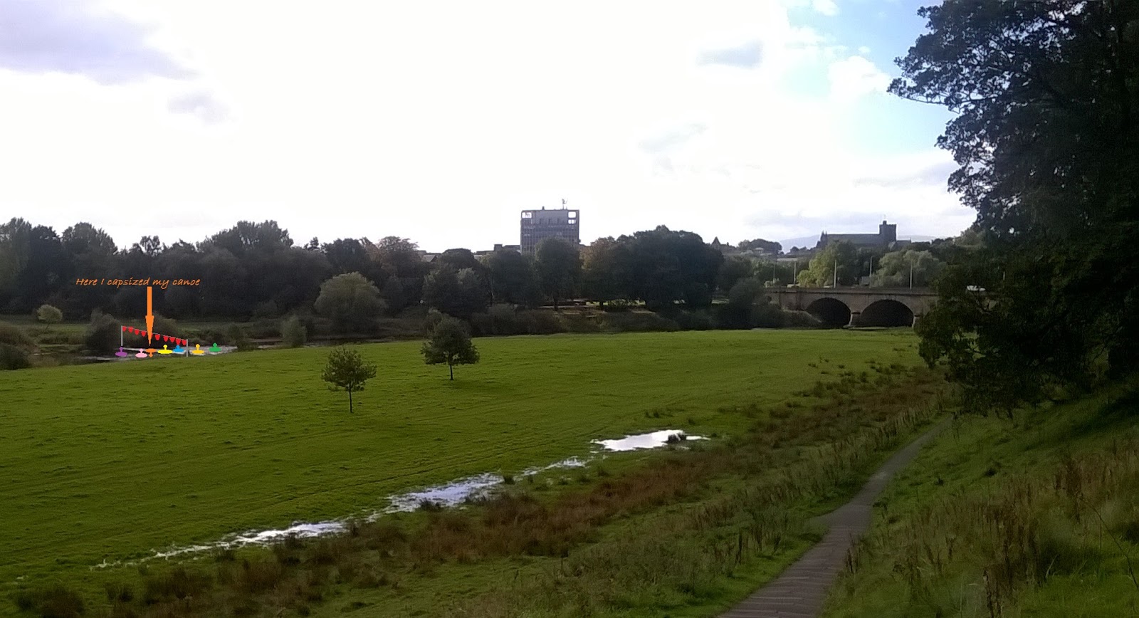 |
| Rickerby floodplain / Carlisle from the North East | Here I capsized my canoe |
The lower Eden is characterised by meanders and holmes, flat semi-islands that are attractive locations for cricket pitches. Whilst the Norse 'holmr' means small island (think Stockholm), here they've become semi islands, dry patches surrounded by marshy/fen land. The shape of the land suggests the river has been flooding for very many years, and the old OS maps of Carlisle have 'liable to flooding' marked on every holme. I remember the water from the same river coming up through our cellar in Temple Sowerby when the water table rose – if there was standing water on the floodplain by the bridge, there would be water in our cellar soon.
Bizarrely, the Google satellite map of much of Carlisle is taken in the immediate aftermath of Desmond, stitched onto the next picture to the north taken at another time, and showing water where water shouldn't be. The roads have been hand-drawn back onto the image.
 |
 |
| A strange rectangular cloud over the city | Floodwater in Rickerby park suddenly ending where the pictures are joined |
One of the things that stuck in my mind post-floods was a magazine writer being annoyed at Carlisle people referring to their bridge that was shut as “Eden Bridges” – when there’s only one bridge. And it’s true, I’ve observed one of my colleagues, who lives over the bridge, calling it Eden Bridges. Search for the reports from 7th December 2015 and half the headlines pluralised the bridge. It’s a folk memory in speech, of when there were two end-to-end bridges crossing this branch of the river, originally known as the Priest Beck, and the branch that ran round the back of the islanded Sands, where the cattle markets and bull baitings were held.
A map forming the back screen at Borderlines shows the old route of the river in the days when the city stayed within its walls and Botcherby, Etterby, Rickerby and Harraby were villages nearby. Transposed onto a modern map, the river route was something like this:
 |
 |
| Carlisle today | The walled city and divided river |
Remembering pre-GCSE Geography and the theory of oxbow lakes, a far as I can currently work out, something like this happened:
- Original route of river meanders, Priestbeck doesn't exist
- River breaks out and creates Priestbeck, probably after a flood event - possibly around 1572 (this sketch map from 1572, south at the top, shows a breach of the river in need of repair, without a bridge over it, where Priest beck would otherwise be). On the other hand, Magna Britannica (1816) reports: "The two bridges over the Eden at Carlisle, called Eden Bridge and Prestbeck Bridge, were of wood in the reign of Queen Elizabeth; when one of them having fallen down, and the other being in a state of great decay, an act of parliament passed for rebuilding them at the expence of the county in 1600. It is probable that they were then first constructed of stone."
- For a time, river flow is divided between the Priestbeck and the Old Eden loop (e.g. George Smith 1746 & 1752 maps , reproduced in Cattle Droving through Cumbria, Peter Roebuck, Bookcase 2016), but eventually the main flow goes over Priestbeck and the Old Eden starts to dry up (in theory forming an oxbow lake which shrinks away over time)
- The island of the Sands is likely to be marshy and prone to flooding (as the 1752 George Smith map suggests), limiting the ways the city could use it
- There are two bridges and frequent calls for them to be repaired and rebuilt throughout the eighteenth century, perhaps indicative of flood damage (and failure to cope with the volume of traffic, notably droving)
- 1807 Act of Parliament approves funding of £10,000 towards the rebuilding of Priestbeck Bridge, given its strategic importance to the northbound road. The new bridge was built 1812-15 and doubled in width in 1932
- Old Eden Bridge (south) was removed "and a raised and partly arched causeway ...formed, connecting the town with the new bridge".
- 1865 OS has a municipal boundary (ward boundary) following (probably) the line of the old Eden. No physical sign of the old river.
- 1898 OS has cattle market, one bridge, old racecourse and the first Hardwicke Circus roundabout which opened in 1892/93. Oddly no Drovers Lane.
- Civic Centre opened 1964, late 1970 new road layout opened (rebuilt Hardwicke Circus, Georgian Way; Castle Way opened in 1974); Sands Centres opened 1985. Presumably further land drainage (building on stilts might have been a good idea) to secure the foundations of these various structures?
Subscribe to:
Posts (Atom)