Seeking serenity – self-reliance on the back-roads – rose-tinted spectacles – the power of nature – solitude – of walks taken before – bilberrying and fashionable foraging– the path less taken – of walks not yet taken and not to be taken – serenity and solitude – of walks taken without me
A friend made a remark about seeking serenity in mountains; after a month of living in Cumbria I’d been cultivating #notjustlakes by spending time on my home patch, the Solway plain, but serenity seemed like a good idea. One of my walk books suggested that Bowscale Tarn is an “oasis of solitude and serenity” at 400m and in the fells that are nearest to the firth. Further investigation revealed the added bonus of a pair of immortal fish, possibly talking (
Ermengarde of Keswick,
Wordsworth and social media in general).
I’m determined to get to know the myriad back roads across the plain, without a satnav (which I imagine would want to send me via the big roads anyway). Reading an OS map whilst driving being somewhat inadvisable, I’m going to have to learn the roads – and pull over periodically when I mess up. I do better this time than last time (get further before going wrong due to the absence of signposts in Thursby) and the views of the northern fells together with hedgerows of meadowsweet and foxgloves make for a great drive – an hour to drive 30 miles. It’s only later that I realise that hedgerows are a largely non-Lake-District phenomenon, and that drystone walls are not county-wide.
The foxgloves in the bracken are very striking and I don’t remember them going quite high up the fells when I was a child. I’m reminded of the nitrogenating lupins in south Iceland. Suddenly realise I have pink tinted sunglasses on, and the foxgloves, rosebay and grasses are not quite so bright in reality as they appear to me.
 |
 |
| Foxgloves, bracken, heather | Foxgloves |
 |  |
| Hawthorn | Hawthorn through pink tinted glasses |
With or without pink tints, it seems the colours for my crochet fell blanket are good – I’m happy that I’ve got a good range of greens, slate grey and sky/tarn/lake blue, together with autumn bracken brown. And saw enough heather to justify its inclusion in the colour scheme.
Finally leaving the Mungrisedale road, I set off up what promises to be an easy riverside track alongside the Glenderamakin river. Until it disappears. A chunk of path 2-3m wide and 15-20m long has disappeared. Seven months on it’s a striking illustration of the December floods. And the priority for fixing roads and paths has been the places where the most people go, not places like this (and it’s not obvious, given the gradient and the bogginess, where a replacement path would go). The Glenderamakin is a river, not a beck, certainly, some 4km long at this point– but not a big river. If this little river can do that much damage, probably in one weekend, it puts into context what glaciers could do over centuries. This is the biggest missing stretch, but not the only one, and the bridge over Bulfell beck is detached from the path at both ends. There are stretches that are recovering from collapses in previous years and also stretches which have collapsed much more recently, with the detached part covered in fresh bracken. The ground is so sodden it’s easy to imagine more collapses and who knows how it will be by the winter.
|
|
|
| The path that isn't | Boulders |
|
|
|
| Old collapse | New collapse |
New mini cairns mark a shoreline path and imply a crossing place – but there aren’t stepping stones and the jump is further than I’m comfortable with. The river is too deep to confidently walk up, so a scramble along the sloppy muddy bank is in order. I’m glad I’m not wearing closed boots – open sided shoes have more flexible soles and it’s easy to wash the inevitable mud layer off. I’m also glad not to be accompanied by a man recovering from an achilles rupture – that would be the end of the walk right there.
The ‘sometimes muddy’ path (i.e. an unculverted beck in the middle of summer) continues on and by the time we reach Bannerdale beck there are two couples and me queueing to cross. I smile and paddle through, hoping to get a headstart on them. The older couple seem a little worn out by the whole effort and I never see them again. The young couple are delayed at the ford for a while but eventually take the same route as me, so after the first period of ascent, I pause awhile and let them pass. This is about solitude, after all. At the bottom of the crags I find a sitting stone set back into the hill giving me a great place to stop, positioned in such a way as not to be able to see or hear anyone else on the mountain, and admire the view down Mungrisedale over to the Pennines.
I’m reminded of many other walks – in the Faeroes, dodging the oystercatcher nests; in Iceland when I had the revelation that their landscape words are ours, and their landscapes are ours a few thousand years ago; in Slovenia and Estonia for greenness and solitude; and in the Jordanian desert where I followed the camel train on foot so that I could let them go round a corner of rock and leave me alone in the desert – and later when everyone sat in rock niches and I had my own niche and could sit far enough back to see no one and play desert music in my headphones (ok wrong desert, but it was one for my desert island (ahem) discs list – as is Manchester Rambler, which I’m singing in my head today).
Bannerdale looks like a cirque without a tarn: certainly glacial, but no moraine to hold water back, and the valley does seem to slope continuously if gently. But see how wet that valley floor is – dark green bog patches halfway up the sides – and this is July – a fairly wet July, but July nonetheless.
When I think they’ve had enough time to get away, I set off again – only to see they’re not that far away and must have taken a break too. But then I see the bilberry leaves, and after some searching, some berries. At which point I have realised I have again forgotten to bring a foraging receptacle – unforgiveable given that most walks involve picking something. Eventually I realise that I shoved the raincoat into a fresh food-bag, and the problem is solved. Collecting berries on a 45 degree slope just adds an extra level of adventure to an ascent. The fact that I have not taken the right hand path advocated by the walk book, but the more difficult left hand route (in fairness, it looked easier at the bottom, and there were more bilberries on the left), makes me think again that it’s fortunate that the man with the broken achilles is not with me today. Looking down from near the top, I can safely say I would not do this route in reverse. I cannot see where I came up and it is alarmingly steep. Engrossed in my bilberries, I’m passed by someone descending the right hand path – I only see him when he’s ten metres below me, and he never sees me at all.
At the top, the view opens to the crowded summits of Blencathra and Skiddaw – there are more people on Blencathra’s summit than
on my route all day. The path less taken.
Taking a break at the summit cairn to admire the 360 degree mountains – and the sight of my firthland home village – I get to thinking
again of walks taken, of walks not taken yet and walks that may never be taken. One of my new colleagues has this week judged that I really am a local (yes! Not an offcomer!) when I relate my pedigree, and I think of the walks taken with and without grandparents, the pictures they had, and their enjoyment of these places (or rather, the southern and western fells). And as we all get older, will
we do the same walks in future? Will I ever do Sharp Edge or will I not find a companion willing or able? My cousins do the high fells of the west; I never have. But I suspect I would delay too much for photos and foraging, so maybe I can never do those walks with them?
The route drops over Tarn Crags – “an obvious path” – indeed, but not one I can walk down, and I have goat-like balance – I take sections
at a crouch. Whilst picking more bilberries. No wonder foraged food is for top quality restaurants, the effort involved in collecting bilberries is uneconomical otherwise. My additional hour en route has produced 120 grams of bilberries – enough to have a few with my garden redcurrants and raspberries for tea, and the rest into a small bottle of gin for some English borovnicke rakija – of which I appear to have four bottles, two homemade by me with Lakeland berries collected by my dad previously. And not yet tasted!
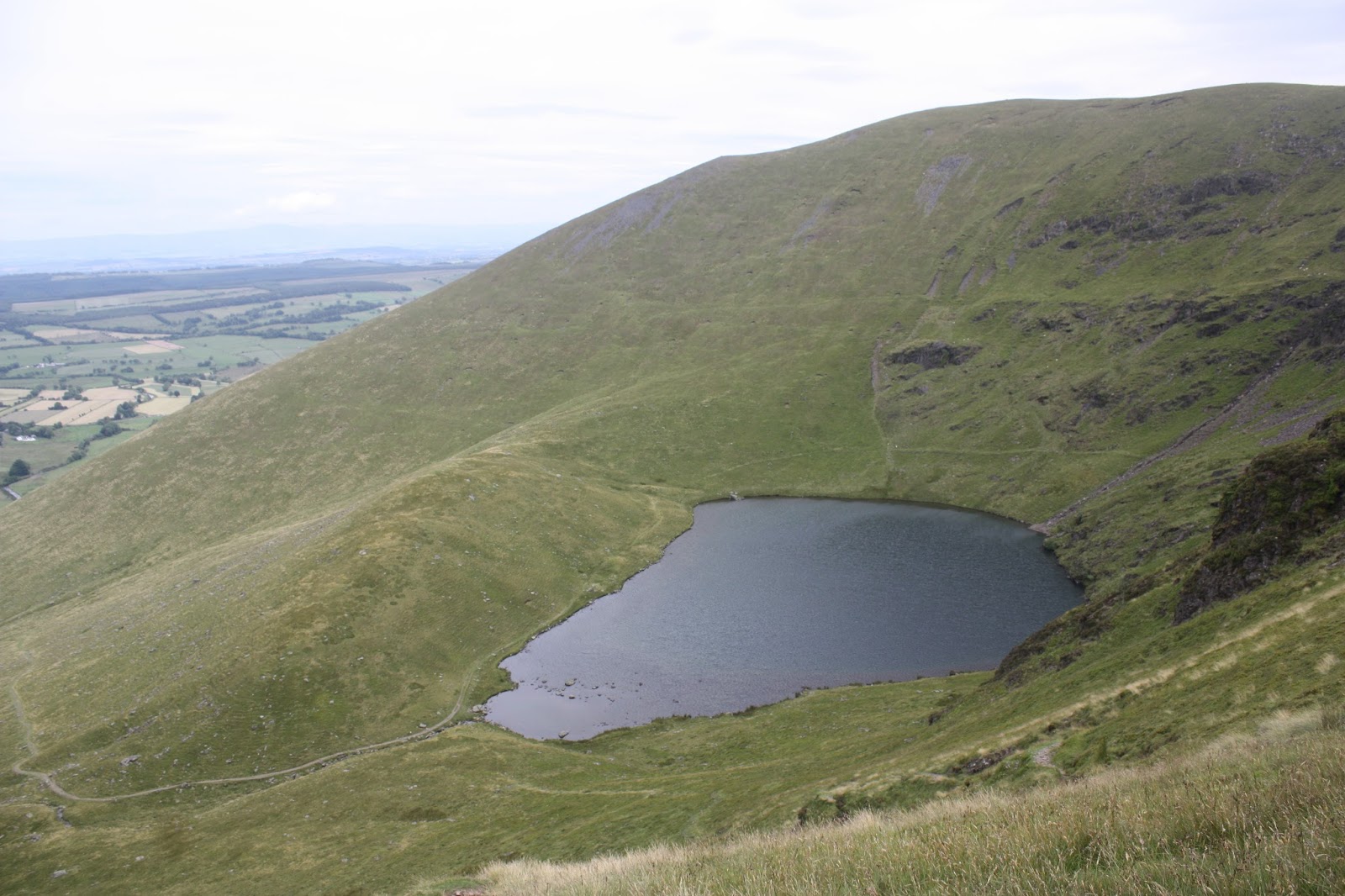
The tarn is a teardrop (
tjorn– small lake or teardrop) or peardrop which is blue in its depths. The circular part is visibly deep, apparently 15+ metres, or a 5-storey house. And it has trout, and two immortal, possibly talking, fish. Sitting on a rock in the shallow end, in the manner of the
little mermaid, I see no fish, but I have an embroidery design in mind to illustrate the tarn and its legends. And (if you discount the evening dog walkers) it
is a serene and isolated place. I had 15 minutes alone on my rock to observe the surprisingly big waves coming from cragside to tarnmouth.
|
|  |
| Bowscale tarn | From the fells to the firth |
The path down is busier, with wheatears and juvenile swallows, and sheep, as well as the dog-walkers.
 |
|
| Ewe looking at me? | Mosedale, Caldew, Carrock |
In the valley, the River Caldew, already sizeable – this is what went on to flood Carlisle in 2015 and 2005. Over there, Carrock fell; I remember a childhood picnic at the bottom, off the road I drove along earlier, and my dad leaving mum, brother and me while he went to climb the fell. He was in his twenties and our legs were too short for fell walking. That didn’t happen often.
Note: Five and a half hours. Baseline 3.75hrs for 10km plus 500m of ascent; add an hour for bilberries and another for photos, reflections and contending with absent paths